| ||||
| About the Tisza-LIFE programme | ||||
| Relation with partners | ||||
| Model-sites | ||||
| Clay-pits | ||||
| Tóalja | ||||
| Tiszajenő | ||||
| Tiszakürt | ||||
| Kőtelek | ||||
| Habitats | ||||
| Implementation | ||||
| Outreach Activities | ||||
| Results | ||||
| Viktória Siposs, Tisza Programme Officer |
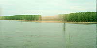
Before the regulation of the river, the Tisza made several sweeping curves in the vicinity of Nagykörű. There are archaeological records of a pre-historic human settlement established on the flood-proof high banks, near today's village. The first historical records of the monastery situated in the village date back to 1212. Three cut-offs were made during the regulation of the river, in 1847- 48, in 1856 and in 1934. That a significant part of the village was destroyed to create one of these cut-offs, which later turned out to be slow to develop, is revealing of the over-zealousness of the efforts. The fok system of Nagy-fok was severed from the river by the new embankment. Although its former riverbeds and lake-basins can still be identified, its restoration would still be a very difficult task. However, there is a smaller fok and a connecting lake included in the new floodplain, which can more easily be restored. It is the Anyita-fok and the lake of the same name, which occupy the low-lying areas of a bay in the floodplain called Tóalja ("bottom of the lake"). After the river regulation, attempts were made to cultivate the area, but it was made impossible by the constant emergence of water during wetter periods. Vegetable and fruit production still flourishes on the sandy soils of higher grounds closer to the river (known as Homoksziget, meaning "sand island") where the ancient fruit varieties (mostly pears) are able to tolerate occasional flooding. The fertility of Tóalja is legendary, as it is commemorated in local sayings. This productivity is due to the periodic inundation that has been going on since ancient times. However, a summer levee was constructed in the 1970s for the (rather short-term) security of agricultural production. [A summer levee is constructed between the riverbed and the main embankment, to protect the area between the latter and itself from the summer floods, which tend to be relatively minor, but can still destroy crops during the growing season.] In 1999, preparations were made to open up the summer levee to facilitate the passing of a major flood. Suddenly, the river got out of control and burst the levee. Since then, the one-time Anyita-lake has re-emerged and the continuation of the unnatural, intensive agricultural practices has become impossible. Such events have provided the opportunity to begin utilising the area in a way, which is more benefical to naure and in a manner based on sustainability. In the framework of the Tóalja Restoration Programme, (which is given support from WWF), it is planned that in time a semi-natural forest will s replace the hybrid poplar plantation (that has been killed by the prolonged inundation) and that degraded fields will be converted (with the help of Hungarian grey cattle), into valuable pastures. This will require some engineering intervention, making it possible to regulate water in a manner more beneficial for nature. With the re-vitalisation of the Anyita-fok, a controllable connection will be established between the river bed and the lake. |
||||||